Kern Canyon 2008: Saturday

Just after six in the morning, just as the moon set over the Western Divide, I left the Jordan Trail, taking the Cutoff Trail that heads over the tail of the Great Western Divide toward Willow Meadows and the Hockett Trail. I followed the trail and a single set of fresh boot tracks, wondering if they might lead me to a stranded hiker. I stumbled across a dozing rattlesnake, camouflaged in the sand of the trail, who barely moved in the cool dawn air.

As I descended over the hump, a helicopter began passing up and down the Trout Meadows kerncol (a kerncol is a type of saddle unique to the Kern Canyon), presumably looking for the missing man.

The luxury campsite at Willow Meadows Junction
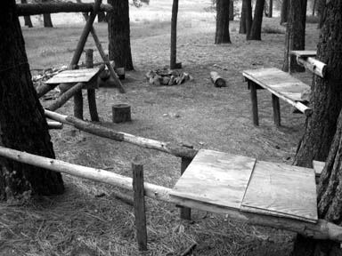
The luxury campsite at Willow Meadows Junction.

The mosquitoes also appeared in force as I neared Kern Canyon. I first noticed them at the Trout Meadows spring, a couple of meadows above Willow Meadows Camp. There were several guys preparing to break camp and continue into the canyon as I was, but I didn’t see any sign of them afterward. I’m guessing they turned back when they got to the bottom of the canyon.

I might have turned back at canyon bottom if I hadn’t been familiar with the route, as the trail had been washed out for about a mile along the canyon bottom, from Leggett Creek all the way to the foot of the ascent to the next kerncol. There were no tracks whatsoever, there was saturated mud everywhere, and the flooding—though subsiding—was not completely over. It wasn’t hard hiking if you had some idea about the general route, that is, if you knew the trail generally keeps away from the river, and had faith that it would eventually reappear.

There’s a good campsite just downstream of Legget Creek that looks like it’s about to be washed into the river, and then there’s the site in the heart of Grasshopper Flat, where Juan and I camped five years ago. I like to refer to that camp as “Scorpion Camp”, in honor of a little critter I uncovered while starting a fire back in 2003.

I veered off the main trail at Little Kern Lake to follow a camp trail that wraps around the lake’s north shore, visiting some nice beaches, and a great campsite at the northwest corner of the lake.

A lovely campsite on the northwest shore of Little Kern Lake
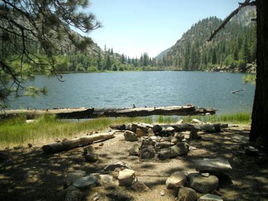
A lovely campsite on the northwest shore of Little Kern Lake.

After Little Kern Lake, I beat feet up to the point where the old trail once followed a kerncol that delivers the traveler directly down to Coyote Creek and the Kern Canyon Ranger Station. It may have been a theoretical shortcut, but there was no trail to follow, so I had to apply a couple corrections to my route finding. Though these kerncols can keep the trail safe from the ravages of rock falls and snowmelt, it seems to me that the old route over this particular kerncol was abandoned for good reason. What a workout! The current trail takes advantage of a lower, less strenuous kerncol which I have sworn fealty to in the future.

Having backpacked fourteen miles since dawn, I was trail weary when I arrived at Coyote Creek. I proceeded across the creek, by way of the huge crossing trunk, and headed down to the river, where I expected to find some backcountry campsites. When I got to the river, I threw off my pack, crossed the bridge into Inyo National Forest, and followed the meandering trail through the manzanita flat above the river. I hadn’t secured my pack against critter depredations, so I soon grew worried and doubled back. I then lugged my pack back to Soda Spring, where I had recalled hearing there was a campground. Soda Spring looked rather murky, and there wasn’t a fire ring in sight, so I decided to return to Coyote Creek. I crossed the creek and unrolled my sleeping bag at the foot of the kerncol that I’d taken in. It would work as a campsite, but I felt a little nervous being so close to the ranger station (no permits).

I had walked around with a bag of M&M trail mix in my hand too long. Many of the M&Ms had melted, leaving the mix resembling a loose, nutty stool.

As I collected my things to filter some water and head down canyon to camp, I was hailed by a young biologist, who directed me to the spot I had just forsaken as a good place to camp. She said she was part of a team that is tasked with removing “invasives”. Feeling a bit like an invasive exotic myself in this restored territory behind enemy lines, I told her “I just want to hug my kids.” She offered me an OREO for comfort, but I told her honestly that I was already full of M&Ms. I was dizzy from fatigue, which is the condition that generally leads me to hiking even more. She headed down trail with her fishing pole. I finished the M&M trail mix and headed down the canyon as soon as the coast was clear.

I camped that night at a nice campsite two miles down canyon, just north of the creek that feeds into Big Kern Lake, which is a humorous euphemism for a huge mud hole and would-be malarial swamp. I prepared to keep a companion fire going, and hoped it would repel the West Nile hummingbirds, as I had no tent to hide in. I saw one playing in the smoke and wondered whether smoke repels them or merely distracts them. No dead crows in sight, though I had seen a silly crow on my way down canyon.

I don’t know what the stars were like that night. I let the little fire smolder, read a bit from the Zoroastrian Journal, took two aspirin for my knee, and fell asleep quite effortlessly.

I did have to stir enough to pump the heat out of my wife’s fancy North Face sleeping bag. I might have done better with a bed roll.

Continue to Sunday

Kern Canyon 2008: Friday

This last full moon, I backpacked up to the Kern Canyon stock bridge in Sequoia National Park. I started at Lewis Camp Trailhead, in Sequoia National Monument, just outside the southern boundary of the Golden Trout Wilderness. This trailhead sits near the top of the Western Divide, on the historic Jordan Trail. For many trips that begin there, the trailhead is the highest point of the trip (7600 feet).

Tulare County SAR Jeep

Tulare County Sheriff SAR Jeep

I pulled into the part of the dirt lot reserved for foot-bound travelers and parked, only to be directed by a Sheriff’s deputy to another spot, to make room for the SAR (search and rescue) workers expected to arrive soon. There was already quite a showing of force: a trailer, a jeep, a couple ATVs, and several other vehicles. Word had it that a man who had been suffering from seizures was lost on the nearby slopes.

About 15 minutes down the trail, I realized that I’d left my wilderness and fire permits in the car. That seemed rather ironic, after having driven four hours to get to the ranger station just before closing time, only to leave the permits in the car. Oh well. Never fails. I always forget something. I decided to take my chances with the rangerfolk, rather than add 30 minutes to my evening hike.

I few minutes later, I encountered a group of cattle, who spooked with no more than a mutual glance, and kicked up a cloud of dust in their panic.

I bounded down the 1900 foot descent, past Jerky Meadow and Jug Spring (a watering hole for animals and the desperate), and arrived at the Little Kern horse bridge just after 8pm, with an hour of dusk to spare. I suffered from a typical spell of outback anxiety along the way, which means I missed my wife and kids terribly and felt guilty about being so selfish as to take this time to myself. Perhaps the evening shadows settling over the mountainside were affecting me. There is something ominous about the onset of nightfall when one has not reached one’s destination, though the night itself can seem quite comforting. Almost predictably, the anxiety disappeared as I settled in for the night.

Horse Bridge across the Little Kern
The bridge over the Little Kern. Note the granite and basalt layers.

Two of the three campsites were occupied by SAR folk, so my choice was easy. I filtered some river water, had some trail mix for dinner, and unrolled my sleeping bag. I enjoyed the warm light of the fire at the camp across the river, laid back, and watched the stars appear one by one.

Antares—the heart of the Scorpion—flared red, like a campfire in the sky, not so remote as the astronomers calculate. I spotted a falling star, and watched a dim, red satellite make its way around and around the planet, first past Lyra toward the pole, then past Cygnus a little while later. Jupiter peeked through the ridgetop trees across the river. The full moon didn’t rise over the tail of the Great Western Divide until I had fallen asleep. I would waken occasionally, as see the Moon chasing Jupiter from west to east.

A full moon can be useful if one needs to get around camp without a light, or if one needs to travel by night, but it can disturb one’s sleep, rather like leaving the bedroom light on, and a moonless sky is certainly preferred by the stars.

Continue to Saturday

The Devil’s Tinderbox

From the first crossing of the South Fork Kaweah River above Three Rivers (elev. 962 ft) to tree line on Hockett Hill above Owens Lake (approx. elev 6700 ft), the Hockett Trail is, with few exceptions, a forested trail. Even the Coyote Pass alternate over the Great Western Divide is well-forested. The only places where trees do not accompany the trail are where it crosses the Malpais lava flow and large meadows such as Tunnel, Mulkey, and Burnt Corral Meadows.

There are few places, however, where the woods that accompany the Hockett Trail could be rightly described as rain forest. Perhaps portions of Garfield Grove might be described as such with some imagination, but the original Hockett Trail didn’t even have that (it was routed below the grove on a sunny ridge).

There are streams, but nearly no lakes. Kern and Little Kern Lakes were born of landslides in 1867/8, after the Hockett Trail’s creation. Kern Lake is more of a marsh at present than a lake, and will soon be a meadow. Little Kern Lake might necessarily need to drop the adjective from its name.

The southern Sierra Nevada is drier than the rest of the range, but there’s no lack of growth, and in many places undergrowth. In fact, the southern Sierra has forests and even chaparral at elevations where there would only be tundra in other parts of the range.

I’ve often encountered forest fires on or near the Hockett Trail. That ought to surprise no one, with all the sunshine and firewood at the ready.

I missed the 2002 McNally Fire, which spared the Hockett Trail, but managed to burn nearby Hockett Peak.

Little Kern Lake during the West Kern Fire.

Little Kern Lake during the West Kern Fire.

The year after the McNally Fire, I had planned to backpack up the Little Kern River, but the Cooney Fire got in the way. My friend Juan and I backpacked up Kern Canyon instead, where we witnessed the West Kern Fire. Two years later, the Kern Fire struck the Kern Canyon. The next time I planned a trip up the Little Kern River was in 2006. That year, the Tamarack Fire got in the way. The Kern Canyon was hit again by the Grouse Fire in 2007. Every one of these 1000+ acre fires—except the McNally—were ignited by lightning.

The Fire Below

Looking back millions upon millions of years ago to the tectonic events that gave birth to the San Andreas fault and California, earth scientists have been striving to determine what forces might have caused the southern Sierra Nevada to lose its root about 3.5 million years ago. It’s a good bet that a range of strange goings on in and around the southern Sierra has been caused by delamination of the subcrustal root of the Sierra: the further uplift of the southern Sierra, subsidence of another portion of the Sierra, tremors and volcanos, and who knows, maybe the 1969 Mets.

One particular event comes to mind: the supervolcanic eruption at Long Valley only 760,000 years ago. You may skeptically inquire, “only 760,000 years?” Bearing in mind that if that infamous supervolcanic explosion-implosion was caused by that splitting of the crust 3.5 million years ago, 760,000 years doesn’t sound like that much. It is as though the initial delamination occurred two weeks ago and a resulting supervolcano then occurred just three days ago.

I don’t mean to venture any conjecture about the probability of major eruptions at or near Long Valley in the immediate future, but rather, I wish to submit that whatever general process existed under the southern Sierra Nevada 760,000 years ago is likely to still be an active process. There’s likely to be something very big going on down there.

What was our first clue?

Perhaps our first clue was the abnormally thin crust under the Sierra.

Where is the crust at its thinnest? Curiously enough, the crust under the Sierra appears to be at its thinnest from around Mount Williamson south to Olancha Peak. This zone includes the highest peaks in the Sierra, and the Hockett Trail cuts right through the heart of it.

Then again, maybe our first clue was the abnormal activity detected in the mantle under Visalia.

The “mantle drip” cell that earth scientists have been investigating lately is thought to be centered approximately below Visalia, and the arc of its circumference cuts deeply into the western Sierra; deepest at the Hockett Plateau. Clearly then, the Hockett Trail cuts through the heart of this zone as well.

Then there’s that other clue: the subsidence that CalTech researchers have identified as roughly centered at the Kaweah Delta. Again, this is the domain of the Hockett Trail.

Oh, and one more thing: why does it appear that the western Sierra is rising west of the Kern Canyon Fault? Could recent activity along this fault, which the Hockett Trail follows from Trout Meadows to Golden Trout Creek, betray some tension caused by convection in the mantle west of that fault?

It seems like a lot is going on under Hockett country.

Watching Whales in the Sink

Much of my childhood was spent in the towns of Hanford and Tulare, in a region once called the Tulare Basin, not far from the dry bed of Tulare Lake. This name “Tulare Basin” might have had more meaning before Tulare Lake was drained for wheat and cotton, but it’s still got that “basin” feel to it, or perhaps “sink” is a better word, with the way the heavier air settles down into it. It’s more than just the southern end of the San Joaquin Valley.

At about the time I became a teenager, I bicycled from Hanford to the brink of the Sierra Nevada, and watched the ghostly hills emerge one-by-one out of the Valley haze. I remember the sense of wonder in coming so close to something other than table-flat. I remember the soft, round foothills jutting suddenly out of the Valley floor like whales breaking the surface of a sea of orange groves.

Whales in the sink

Whales east of Cutler, California

There’s a remarkable story behind those whales that I had not heard about until quite recently.

I was taught in college that the earth’s crust is thicker under continents, and thickest under mountain ranges. Think of it as a characteristic of any floating object: the more that you see floating over the surface, the more there is under the surface; only there’s much more under the surface, as with an iceberg.

It turns out that this is not the case with the southern Sierra Nevada. This mountain range is more like a catamaran than a conventional boat. Under the highest portion of the Sierra, the crust is thinner than 30 km, and the crust doesn’t exceed 35 km in thickness under most of the crest of the High Sierra, as well as the Great Western Divide. All this is thinner than the crust is under Fresno.

The Sierra Nevada is hence thought to have lost its root. Layers under the range are thought to have separated, or “delaminated”. If this occurs to an iceberg, one would expect the iceberg to settle down into the water a bit, but that all depends on the relative density of the ice and the water. What happens when a mountain range looses its root? What happens if chunks of crust are dropped into the upper mantle? Some geologists appear to believe that delamination under the Sierra may have created a deep convection cell that led to even more uplift, and possibly an ancient supervolcano. What’s more, that convection cell appears to still be around, and very much alive.

Root loss, mantle drip, and the Moho hole.

Root loss, mantle drip, and the Moho hole.

Let’s take a conceptual hike. Start at Long Valley Caldera, where one of the world’s great volcanic events occurred 760,000 years ago. Walk across the Mammoth divide, past Devils Postpile National Monument, and down the San Joaquin River to Fresno. For much of your hike across the western slope of the Sierra, you will be waling over another anomaly: there is no clear boundary between the crust and mantle beneath your feet: you’re crossing the “Moho Hole”. You’re also walking over a gigantic “high-velocity drip” convection cell. In some areas, the convection cell presses up on the crust; in other places, pieces of the crust are dripping down into the mantle.

So what does all this have to do with whales?

Look at those whales east of Visalia, then look at the foothills along other parts of the western Sierra Nevada. The latter emerge gently from the plain, but the former shoot right out of the Valley floor like sinking ships, and that’s just it: they must be sinking, and there’s more than thirsty farms at work here. As they sink, sediments from Sierra streams settle in around them, burying the the foothills themselves. What we see, then, are not foothills but mountains.

The Tulare Basin is more than just a stagnant basin that happens to be adjacent to the Sierra Nevada: it is part of the Sierra, and not just because it sits on the low end of a great granitic incline. Likewise, the southern Sierra Nevada is much more than just a giant slab of granite. When realizations like these dawn upon us, so too are we reminded that science is more than an accumulation of knowledge: it’s a thing of beauty.

Don’t take my word for it, of course. No doubt I’ve read some of the science wrong. Read it for yourself and let me know what you think:

George Zandt, University of Arizona, 2003:
The Southern Sierra Nevada Drip and the Mantle Wind Direction Beneath the Southwestern United States


George Zandt, Hersh Gilbert, Thomas J. Owens, Mihai Ducea, Jason Saleeby & Craig H. Jones, in Nature 432, 2004:
Active foundering of a continental arc root beneath the southern Sierra Nevada in California


Jason Saleeby and Zorka Foster, CalTech, 2004:
Topographic response to mantle lithosphere removal in the southern Sierra Nevada …


Elisabeth Nadin and Jason B. Saleeby, CalTech, 2005:
Recent Motion on the Kern Canyon Fault, Southern Sierra Nevada, California … (link broken)