Trout Meadows: the old crossroads of the southern Sierra. Here’s where three trans-Sierra trails crossed: the Dennison, the Jordan, and our Hockett Trail. This is also where the eastern leg of the Hockett Trail begins, and the western leg ends. This is no arbitrary division: the Hockett Trail can very easily be seen as two trails that meet at Trout Meadows.
“The evidence indicates that main-traveled trails from Kaweah and Tule villages led to a common meeting ground near the junction of the Kern and Little Kern Rivers (Round Meadow – Trout Meadows area). If you wished to travel eastward you would travel one of several trails that converged on this meeting place from several Owens Valley points.” — Floyd L. Otter, Men of the Mammoth Forest, pgs. 27-28
As early as 1923, plans were published that would have had the entire eastern half of the Hockett Trail widened and graded for automobile traffic.
The new road, which is to run from Lone Pine in the Owens Valley, up into the high Sierras through Carroll Creek and over Mulky Pass, going westward to the heart of the Kern River country. — Los Angeles Times, November 7, 1926
This was all very exciting, but getting a road built even as far as Horseshoe Meadows proved to be quite a challenge. In 1929, Los Angeles road crews, ever in search of more water resources to exploit, were turned back by the cliffs below Wonoga Peak. Imagine that! The thirsty City of Los Angeles defeated by an engineering challenge!
The road that LA started didn’t get to Horseshoe Meadows until 1967. It may have never made it that far if developers had waited any longer, that being a bygone era. The Hockett route was challenging enough for pack trains; it proved quite prohibitive for auto traffic.
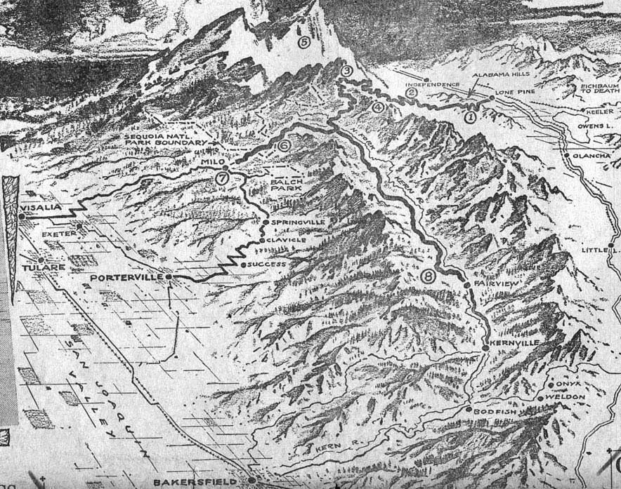
The ambitious plan included a branch over Coyote Pass as well. It appears that this branch would have continued along Windy Ridge and Dennison Ridge to Milo (what was known ca. 1900 as the Dennison Trail).
Part of the old Jordan Trail would also likely have been part of that grand trans-Sierra project. That would be the segment of the Jordan Trail that backpackers, packers, and equestrians take from Lewis Camp Trailhead to Trout Meadows (33E01). This is another convenient river access point along the Hockett Trail, particularly via the Willow Meadows Trail (trail 33E14).

From Trout Meadows, the trail heads directly north along the Kern Canyon Fault toward Kern Canyon, where it drops to canyon bottom.
While descending into the canyon, the trail meets a trail (33E05) that drops into the “Hole in the Ground”, certainly a worthwhile side trip for anglers.
Continuing along the Kern Canyon Fault, the trail occasionally striding over distinctive saddles called “kerncols” that keep the trail from the more rugged canyon bottom. The canyon offers a number of good campsites, the most exquisite being those adjacent to Little Kern Lake.

Just before entering Sequoia National Park, the present-day trail veers away from the old trail by staying close to the river, whereas the old trail rose over yet another saddle. The present-day route is more scenic, but perhaps not quite as practical.
See Exploring the Southern Sierra: West Side by Jenkins & Jenkins: Coyote Lakes Backpack (T58) and Two Rivers Backpack (T59). Also see Hiking California’s Golden Trout Wilderness by Suzanne Swedo: Trout and Willow Meadows (10) and Little Kern Lake (14).
Some details about the route:
The descent into the Canyon from the Trout Meadows kerncol can be made directly down a rough, rocky, and sometimes overgrown trail, or down a longer dirt trail that turns east over the canyon and then descends easily along the forested slope below the more treacherous alternate.
The present trail to Hole in the Ground strikes the main trail just south of Angora Creek, which is a fine spot to get a drink. The old trail to Hole in the Ground appears to have struck the main trail at canyon bottom, closer to Leggett Creek.
Once in the canyon bottom, if the trail has been washed out, stay close to the base of the canyon wall, and away from the river.